News
Pasaia, 10 de julio de 2024- Existe, por parte de las administraciones públicas cercanas a la costa, la necesidad de nuevas herramientas que ayuden a enfrentar no solo la complicada gestión de las playas, sino también a prever situaciones ambientales vinculadas al cambio climático, como el aumento del nivel del mar o fenómenos meteorológicos adversos.
Pasaia, 10 July 2024 – Coastal public administrations need new tools to help them not only with the complex management of beaches, but also to anticipate environmental situations linked to climate change, such as rising sea levels or adverse weather phenomena.
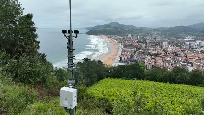
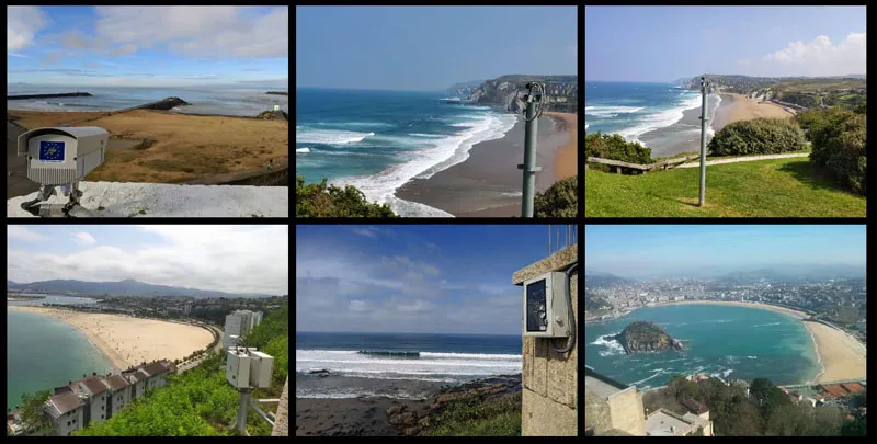
To fill this gap, the AZTI technology centre has developed KOSTASystem as part of the KOSTARISK cross-border laboratory (made up of the University of Pau and the Pays de l’Adour, the SUEZ Rivages ProTech centre and AZTI). KOSTASystem is a videometric coastal monitoring system using a technology that combines video cameras powered by solar panels and artificial intelligence image processing algorithms.
Currently, 35 KOSTASystem stations are monitoring the coasts of Spain and France to help coastal population institutions understand and observe the effects of climate change and make decisions based on these risks.
‘The tool offers those responsible for coastal management a system for monitoring coastlines and sandbanks that is more efficient and economical than other traditional techniques such as topography,’ explains Irati Epelde Pagola, an expert in oceanography at AZTI.
Among other aspects, the KOSTASystem camera network carries out morphodynamic monitoring of the sandbanks, i.e. it monitors the beaches and evaluates how the coastline evolves and the changes that occur over time in the shape of the beach, the loss of space or the distribution of the sand.
‘The indicators are also used to adjust and validate numerical models that can be used to analyse future scenarios and the evolution of beaches in response to rising sea levels,’ adds the AZTI expert.
The system also monitors in real time the impact of waves and their effects on ports and other coastal infrastructures, such as boardwalks.
In this way, it is possible, on the one hand, to predict the impact of storms on the coast and validate early warning systems for storm events and, on the other hand, it facilitates progress in the design of measures aimed at mitigating their effects, both in the short and medium and long term.
This is in addition to monitoring the dynamics of the coast in relation to the marine litter collection, providing conclusions on the effects of these environmental actions on the coastline.
IKOSTASystem can also be an ally of the lifeguard services on beaches thanks to its ability to detect and predict undertow currents in the sea. This technology, which has been used since 2013 by lifeguards on numerous beaches along the Basque coastline, was extended to the Canary Islands in 2024.
The technology provides beach guards with the exact location of dangerous currents and predicts circulation patterns using numerical models. This is useful to help lifeguard services and thus ensure the safety of bathers,’ Irati points out.
Finally, video monitoring makes it possible to track the occupancy density of beach users, calculate attendance and draw up annual reports to draw conclusions about behaviour patterns and the busiest areas.
Finally, video monitoring makes it possible to track the occupancy density of beach users, calculate attendance and draw up annual reports to draw conclusions about behaviour patterns and the busiest areas.
During the COVID-19 pandemic, at the request of the Environment Directorate of the Provincial Council of Gipuzkoa, this tool was adapted to provide real-time information on the occupation of beaches, to ensure compliance with the capacity recommendations. Currently, this application, called ‘Nik Hondartzak’, is still in operation so that all users can consult the occupancy level of the beaches free of charge before visiting them.
In the summer of 2024 Las Palmas de Gran Canaria has joined this initiative by launching the LPA Beach app. This application provides real-time information on tides, occupancy, weather and services available on the beaches of Las Canteras, La Laja and Alcaravaneras.